Earthquake Memorial in Sichuan
Earthquake Memorial in Sichuan
On 12 May 2008 the devastating earthquake in Sichuan Province of China destroyed thousands of lives within minutes. The affected area lies just a little more than one hundred kilometres north of Chengdu at the foot of the Himalayan Mountains. More than 70,000 people were killed and an additional 18,000 are still missing. 350,000 people were injured and the disaster left 4.8 million people homeless. The national government immediately initiated a huge rebuilding programme to provide shelter and infrastructure.
Overview
One of the most severely hit areas was Beichuan County, where over eighty per cent of the buildings collapsed and more than 15,000 people were killed. Among the buildings that collapsed was the Beichuan Middle School in which more than 1000 pupils and teachers died. The government decided to build the National Earthquake Memorial on exactly that spot. The architecture faculty of Tongji-University in Shanghai was given the commission to organize a competition among their faculty members. After several rounds of negotiations the first prize was awarded to Cai Yongjie, who proposed a memorial landscape with integrated museum. The integration of the buildings into the landscape was what finally persuaded the jury. To build a memorial without a dominant building and a huge square in front of it, is quite unusual in China and reflects the shock of all the decision makers.
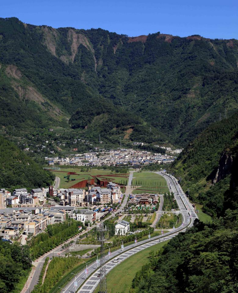
Memorial from the air
The new memorial landscape spans across the whole valley on a sloping level and is bordered on one side by a small road and on the other by a four-lane highway. Beyond the roads the landscape rises steeply and is covered with forest. Within the valley the road leads to the remains of old Beichuan Town; the ruins were kept as a memory for the people. As a place for official ceremonies and private mourning, the new National Earthquake Memorial covers almost fifteen hectares. It includes a museum and service spaces as well as open air facilities embedded in the park-like landscape.
Panorama with neighbouring landscape
Although the administration ordered the removal of the ruins of the collapsed school buildings, the designers integrated the footprint of one building as well as the sport field into the concept. The former sport field was turned into a memorial courtyard for private ceremonies. An organically formed mound covers the left over ruins of one of the school buildings and the former entrance gate to the school became the spot for the beginning of an axis towards the memorial courtyard. These traces are engraved into the sloping landscape and refer directly to the experience of the earthquake and its effects. As many experts afterwards agreed, more than 5000 students in the region were killed by collapsed schoolrooms due to corruption during construction that led to an unsafe use of building materials. For this reason, the local as well as the regional administration had no interest in keeping any memories about the failure of their own system. Covered under the name of land-art for the memorial, the traces still testify to the political failure.
Detail
Cai’s proposal represents the earthquake as a huge green grass surface in which cracks are symbolically integrated as paths for the circulation of the visitors. From the entrance side the landscape rises smoothly and the pedestrian routes become sunken ways between warm brown walls of Corten steel, which cover the facilities behind. The visitors are led to the entrance of the museum, to service facilities and to the memorial courtyard. The network of paths across the area allows access without hierarchy and the main entrance court is indicated only by a small clock tower. The paths are paved with slate slabs and provide benches for rest, whereas the actual entrances to the buildings are rather unspectacularly integrated into the covering of the weathered steel of the façade.
Brown and green
Besides the smooth green grass, the rusty tone of the slate paths and the brown of the rusty steel, the landscape is defined by the planting of dawn redwood (Metasequoia), which will grow to a height of sixty meters. The spatial concept in combination with the surface materials and the planting resulted in an unusual memorial for the local residents as well as visitors from afar. It keeps memories alive and offers space for reflection of real human feelings and questions. Such a memorial is meaningful and gives back dignity to those who survived, even if their request for visible elements of the human failures that led to the disaster are only covertly inscribed in the overall layout of the landscape.
Entrance plaza with clock tower
Entrance plaza with clock tower
Sunken path
Entrance path for service and museum
Benches
Main entrance to the museum
General layout
Analysis of spatial relationship
Ground floor plan
Sections
Text by Eduard Koegel
Architect
CAI Yongjie, Tongji University
Architectural firm
Tongji Architectural Design and Research Institute
Landscape architecture
Tongji Architectural Design and Research Institute
Design Team
CAI Yongjie (Project leader and designer for architecture, interior and landscape); CAO Ye (architect), LI Xueping (statics), SUN Feng (electricity), GONG Haining (water), MAO Huaxiong (heating)
Photographer
CAI Yongjie


